A day in the Centre, in Uluru-Kata Tjuta National Park:
‘My nose was cold, the rest of me snug, as I lay in my swag, watching stars fade, listening to dingoes howl, smelling the smoky campfire – it was 5 am.
An hour later, we reached the Kata Tjuta (Many Heads) sunrise viewing area, about 30 km west of Uluru. Even at this distance, the shadowy monolith was an inspiring sight, while to the north, Kata Tjuta remained dark and imposing. The lookout was well located. Depending on the time of year, the sun would appear to the left or to the right of Uluru, or directly behind it, a special moment as it crested the summit. But would it do that today?
About 80 other earlybirds were also enjoying the spectacle. The crowd was upbeat, anticipating something special on this grand outback stage. The lightening sky turned pink behind Uluru, reflecting off straggling black clouds, while the rounded domes of Kata Tjuta started to differentiate in the pink half-light, taking on purple shades reminiscent of an Albert Namatjira masterpiece.
The pinky-orange glow intensified to the left of Uluru, so there would be no summit dawn today. Pink surrendered to yellow as the sun broached the desert horizon. As the first weak rays of light touched Kata Tjuta, deep purple faded and the domes took on their daily garb – Many Heads became many reds.
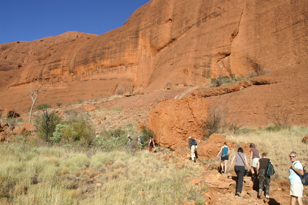
We drove to Kata Tjuta, where we walked the Valley of the Winds, a 7.4 km track winding through steep-sided domes. Lindsay pointed out several acacias: the wine glass mulga, its leaves tough and narrow to reduce moisture loss; the witchetty bush, host of the famous grub; and dead finish (named for the fact that its spiky phyllodes killed many cattle in days past). Judging by the numerous grass nests, the spikes didn’t deter zebra finches. These pretty seed eaters don’t stray far from water, important knowledge for Aboriginal desert dwellers and early white explorers.
The track started well but then deteriorated, the loose stones hard to walk on. Our group, ranging in age from 16 to 73, took it in their stride, all being reasonably fit. We passed through Karu Lookout, and stopped beside a red gum-lined watercourse, at first glance mistaking bunches of mistletoe for eucalypt flowers.
Lindsay found a small sharp stick and drew the first of many ‘mud’ maps in the warm red soil as he explained how Many Heads was formed. Behind him, 30 zebra finches flew into a muddy puddle to bathe and drink.
We passed an emergency radio transmitter – easily visible with its white cross on a green background. The transmitter was erected in response to deaths caused by visitors becoming lost and succumbing to the furnace-like heat. A steady climb led to Karingana, looking over a sparsely vegetated plain with several of Kata Tjuta’s heads in the near distance.
Uluru and Kata Tjuta were once called Ayers Rock and the Olgas respectively, named for Europeans who never visited. They complement each other in many ways. Uluru is one rock, Kata Tjuta many; Uluru is sandstone, Kata Tjuta conglomerate; Uluru you go around or (preferably not) over, Kata Tjuta you go through; and for Indigenous people, Uluru is more a women’s site, Kata Tjuta a men’s site. I’ve always preferred Kata Tjuta due to its rugged nature and relative solitude. And now that visitors have been pushed away from the base of Uluru, my preference for Kata Tjuta is even stronger.
We returned to the bus, tired but happy. Next stop was Kings Creek; two notable things happened en route.
We stopped at the Mount Conner Lookout as we headed east along the highway. On the northern side, hidden from the road behind a sand dune, was the southeastern edge of the huge, blindingly white Lake Amadeus saltpan.
Another bus had arrived before us; I recognised someone.
‘G’day Pierre’ I said, ‘fancy meeting you here.’ I asked him about their Uluru tour.
‘It was great; you know, while you can read about places like Uluru and see the photos, nothing compares to actually being there. And we were happy to stay on the ground but the base walk was disappointing.’
‘Why was that’ I asked, keen to hear the park veteran’s views.
‘Well, if the Aboriginal owners don’t want people clambering over Uluru, they have to provide a good base walk alternative. Several fenced-off sites had no interpretation. It should be possible to provide general information that would not impinge on the sanctity of the sites.’
A valid point: when our group went to Kantju Gorge the previous day, Lindsay had explained the spiritual significance of the Warayuki women’s site nearby. It was fascinating, and enhanced the experience. Presumably it could be made available to all visitors, not just a select few.
Pierre’s bus left and soon we were also on our way, leaving the Lasseter Highway and turning north onto the Luritja Road.
After the 5 am start and the walk in the heat, we were in various stages of snoozing when Lindsay suddenly hit the anchors and quickly reversed. We were instantly awake, curious to know what he was up to.
He stopped, leapt out and picked up something. We quickly joined him and saw that he was gingerly holding a thorny devil – a small spiky lizard with large spurs around the head and neck, giving it a Jurassic Park-like appearance. It was beautifully camouflaged in various shades of brown and cream. Canadian Meghan bravely posed with it on her bare shoulder while the rest of us took snaps. Despite its ferocious appearance, the thorny devil is a passive little chap, and one that I saw at Desert Park was using its rapid-fire tongue to deftly catch ants crawling over its spiky body. The taxonomist who named it was clearly not a fan, giving it the unflattering scientific name of Moloch horridus.’
Hope you enjoyed your visit. The pic shows our group walking at Kata Tjuta
Happy travelling.